How is the way people move around cities changing?
Over the past decade or more, cycling has become an increasingly important part of the urban transportation scene. Peterborough is no exception to this trend. In a smaller city such as ours comes greater accessibility to a wider range of activities than might be found in a city such as Toronto—to education, work, shopping, leisure, and events. In fact, some 77 percent of trips in Peterborough are less than five kilometres long—making many trips ideal candidates for cycling.
Many cities have now made cycling infrastructure a hallmark of their transportation plans. The trend towards increased cycling for a wide variety of trips has accelerated with the onset of the Covid-19 pandemic. Climate change, public health, and social equity considerations are also compelling cities to re-examine how people move.
Decades of experience across North America and beyond have refined the different ways cyclists can be accommodated on city roads. An emerging model of “all-ages-and-abilities infrastructure” is based on three principles: it is safe and comfortable to use, and it is equitable in serving low-income and underserved communities.
Peterborough has unique circumstances, such as a high seniors’ population and areas of lower-income that make this model of infrastructure especially compelling. We in Peterborough can benefit from this experience, adapting these guidelines to our own circumstances.
What does “all-ages-and-abilities infrastructure” look like?
Each road, the traffic it carries and community it traverses, is unique. In downtown and older areas, narrower roads and rights-of-way generally reduce the area available for cycling. In suburban areas of four lane roads and high traffic volumes, more space is generally available for independent cycling infrastructure that reduces conflicts between motorists and cyclists.
Regardless of the varying characteristics of Peterborough streets and neighbourhoods, the design principles of “all-ages-and-abilities infrastructure” can help create an equitable network that serves everyone both safely and in comfort. This concept—an important component of the “Complete Streets” concept described elsewhere on the PBAC website—tailors five basic design “templates” to the type of road and its traffic speed, volume, and context, as follows:
LOW-SPEED SHARED STREETS are used in cases where pedestrians and cyclists outnumber vehicles. They are designed to accommodate cyclists and pedestrians anywhere on the road and maintain low traffic speeds for vehicles and cyclists—typically no more than 15 km/hr. Materials and markings are sometimes used to delineate road space. To-date, Peterborough doesn’t have an example of this approach, although periodic street closures for downtown events such as those on George and Hunter streets come closest to how this model might work.


Above images © pedbikeimages.org: Ryan Snyder, (first image); Dan Burden (second image)
BICYCLE BOULEVARDS feature low vehicle speeds (less than 40 km/hr) and volumes and are typically found on local residential or narrow streets. Bicycle markings on the pavement and bicycle route signage can alert motorists to the shared nature of the street and provide cyclists’ orientation. Occasionally traffic calming features are used such as speed tables and chicanes to naturally slow traffic and bicycle priority measures at major or other intersections.


Above images: © Rochester Subway, Payton Chung (first image); © Cycle Toronto (second image)
BUFFERED & CONVENTIONAL BICYCLE LANES involve the painted delineation of a separate bike lane on the road pavement intended for the exclusive use of cyclists. They are used on streets with higher traffic volumes to reduce vehicle/cyclist conflict. Bicycle lanes can be demarcated from vehicle lanes by way of a single painted line or a striped “no-go” boulevard. Over the past several years Peterborough has added many examples of conventional bicycle lanes such as those on Monaghan Rd and McDonnel St. The recent bicycle lanes along George and Water streets downtown are examples of buffered bicycle lanes.

Conventional bike lane on Parkhill Road

Buffered bike lane on Water Street

Conventional bike lane on Ashburnham Drive
PROTECTED BICYCLE LANES enhances the horizontal separation of buffered bicycle lanes by adding vertical physical barriers such as flex posts, curbs, and even parked cars. This combination of horizontal and vertical separation removes most stresses associated with on-road bicycling. Protected lanes are now considered best practice on streets with speeds greater than 40km/hr and can be used in a variety of situations, from two-lane roads to high-volume, four-lane roads. The rigour of measures varies with the magnitude of safety required. Peterborough has experimented with this form of bicycle lane in a short stretch on Sherbrooke St. and the demonstration lane on George Street between London and McDonnell streets.

Protected bike lane on George Street

Protected bike lane on Sherbrooke Street
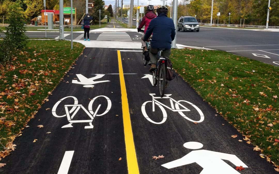
SHARED-USE & BICYCLE PATHS completely separate cyclists from the road and traffic. They can follow former rail corridors or linear parks, or may parallel a road. They are ideal in areas that have plenty of space and where road or cycling traffic is high. Unlike bicycle lanes, these pathways are shared with pedestrians and other users (separate bicycle and pedestrian paths are recommended in areas of high pedestrian volume, where space permits). Peterborough has a wealth of shared-use pathways, some of which were the first in our growing network of all-ages-and-abilities infrastructure. Examples include the rail trail in Jackson Park (part of the Great Trail), the Parkway Trail east of Jackson Park, and multi-use pathways paralleling Ashburnham Drive and the Parkway.

Rotary Trail shared-use pathway

Protected bike lane paralleling Ashburnham Drive
What do we want to achieve with these different types of cycling infrastructure?
A successful cycling network serves people of all ages and abilities, including children, seniors, women, people of colour, and low-income and disability communities. It connects different types of cycling infrastructure and different parts of the city—such as downtown and destinations such as Trent University and PRHC—in a manner that is safe and comfortable for all users.
Whereas some parts of the city are well-served by cycling infrastructure, there is work to be done elsewhere. Access from the city’s north and west ends, for example, does not currently provide the safe, comfortably, and equitable access embodied in all ages and abilities infrastructure.
What does PBAC want? The city is now undertaking a cycling master plan that will help to address deficiencies and create a complete cycling network. The plan and network will also include design guidelines that set the “default” for the City’s transportation planning and influence the types of cycling infrastructure Peterboroughians will use in future. PBAC wants to ensure existing and future roads embody all ages-and-abilities infrastructure design to make cycling in our city an accessible, viable option for all.
In the meantime, street improvements continue, and we must advocate to ensure these improvements do not preclude the incorporation of cycling infrastructure now, or at some point in the future.
What can I do to help cyclists are guaranteed a place on Peterborough roads?
Let your local councilor know that safe, connected, and convenient cycling infrastructure is important to your health and well-being and that of the city! Encourage them to be involved in the city’s cycling master plan, to support all ages and abilities infrastructure, and to ensure projects today can fulfil the future vision for cycling in Peterborough. You can follow progress by signing up for the PBAC newsletter.
Contribute to the City and County’s Transportation Master Plan Updates, both currently underway! (Incl links to our issues on each topic, and/or links to the official sites)
How can I find out more about different types of cycling infrastructure?
There is a wealth of material on modern cycling infrastructure design. You can find out more at these links:
https://nacto.org/publication/urban-bikeway-design-guide/
https://nacto.org/publication/urban-bikeway-design-guide/designing-ages-abilities-new/